
Is a playground still a playground when it gets too hot?
When we think about whether a neighbourhood is suitable for children, we often look at the number of playgrounds, parks and other public spaces available. But having a playground nearby does not necessarily mean that children can comfortably use it throughout the day. During periods of extreme heat, the availability of shade, the location of trees and the amount of exposed space can become just as important as the playground itself.
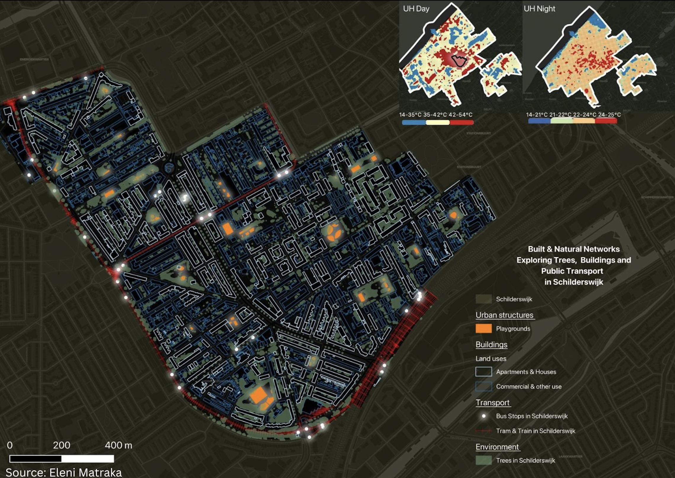
We explored this question in Schilderswijk, The Hague, using GIS to look at the relationship between playgrounds, trees and heat. Schilderswijk provided an interesting case because of its dense urban environment and exposure to high temperatures.
Looking beyond the playground
We brought together different layers of information to understand the neighbourhood from several perspectives. Most of the data came from the Municipality of the Hague’s open-data platform, including information about playgrounds, public transport and heat. We also used spatial data on trees and buildings to examine how these elements relate to children’s public spaces.
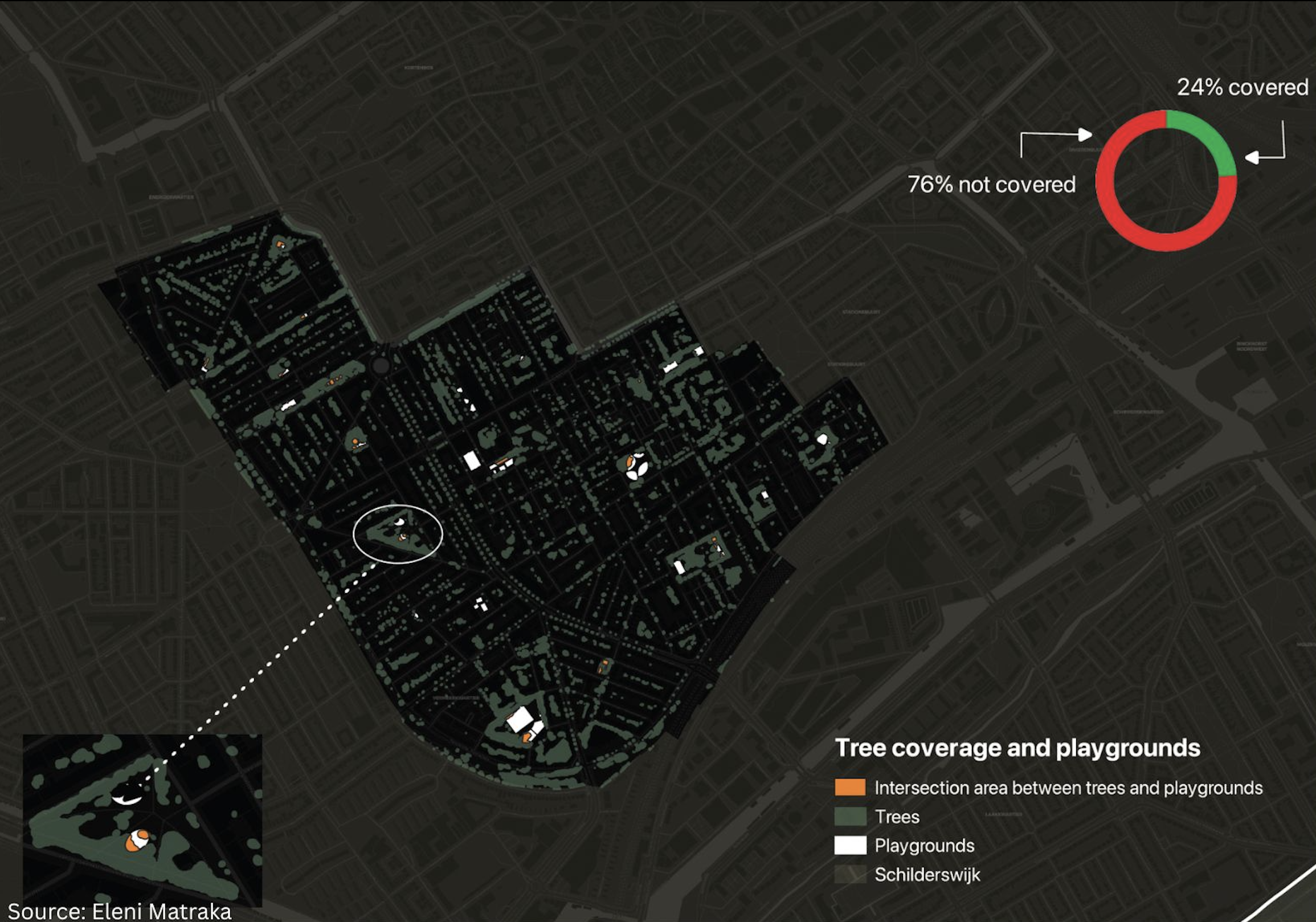
One of the main questions was relatively simple: how much of the playground space is potentially shaded by trees?
Our analysis showed that approximately 24% of the combined playgrounds area overlapped with the areas identified as potentially shaded by trees, while around 76% did not. This does not mean that 76% of the playgrounds are unusable, nor does it represent the exact amount of shade at every moment of the day. Rather, it gives us an indication of how limited tree shade can be across the playground areas we analysed.
This finding made us think differently about how we measure access to children’s spaces. A map can tell us that a playground exists, but it cannot tell us whether it is a comfortable place to spend an afternoon in the middle of summer.
It is not only about how many trees there are
When we talk about greener cities, we often focus on the number of trees or the amount of green space. These are important indicators, but their location also matters. Trees around the edges of a playground do not necessarily provide shade where children play or where parents sit.
For a child, this can mean that some parts of the playground are much more comfortable than others. For a parent or caregiver, the availability of a shaded place to sit can influence how long they are willing to stay. During a particularly hot day, these small differences can have a significant effect on how public space is used.
This suggests that urban greening should not only be about adding more trees, but also about thinking carefully about where their shade is needed. When playgrounds are designed or renovated, the position of trees, seating and play equipment can all influence whether shade is available where people actually spend time.
Heat can affect children’s independence
There is another reason why this matters for child-friendly cities. We often discuss children’s independence in relation to traffic and mobility: can children walk or cycle to school, visit friends or use their neighbourhood without an adult?
Extreme heat can create another, less visible limitation.
A child may have a playground within walking distance, but if there is little shade and the surrounding area becomes very hot, the practical opportunity to use that space changes. Parents may choose to visit at a different time, stay for less time or avoid the playground altogether. For children, this can mean fewer opportunities to play outdoors, meet friends and spend time independently in their neighbourhood.
Climate adaptation is therefore also connected to children’s everyday freedom to use the city.
What a map cannot tell us
At the same time, the GIS analysis has clear limits. It can show us where playgrounds and trees are located and help us identify areas where they overlap. It can also help us understand how these spaces relate to wider patterns of heat and accessibility.
But it cannot tell us how children actually experience these places.
It cannot tell us whether children avoid a particular part of a playground because it is too hot, where they prefer to play, or what kind of shade they would actually like. It cannot tell us whether a parent chooses one playground over another because there is a comfortable place to sit.
This is where children’s perspectives become important.
Data can help us identify where to look, but children’s experiences can help us understand what we are seeing. A map may show limited shade in a playground. Talking to the children who use that playground can tell us whether this actually affects their behaviour and what they think should change.
Designing public space for a hotter city
The answer is not necessarily to cover every playground with trees. Different spaces will require different solutions, and shade can be provided in many ways. What matters is that children’s comfort is considered alongside more traditional questions of accessibility, safety and available play space.
More detailed tools, such as solar radiation modelling, could help cities understand how shade changes throughout the day and across seasons. But even a relatively simple spatial analysis can reveal relationships that are easy to overlook when datasets are considered separately.
For us, this is one of the valuable things about using GIS in urban planning. It does not provide all the answers, but it can help us ask better questions.
A playground may exist on a map, but what matters to a child is whether they can actually enjoy being there. As cities become hotter, creating child-friendly public spaces means thinking not only about where children can play, but also when, how and under what conditions they can use those spaces.